
Around Warburton you can experience the majestic mountain ash and manna gums overlooking the valley with visiting wildlife including wallabies, wombats, echidnas, koalas and glider possums. The bird life is prolific with king parrots and crimson rosellas, superb lyrebirds, kookaburras, Major Mitchell cockatoos, Gang-gang cockatoos, Black cockatoos and the list goes on.
LOOKING FOR SATURDAY - SUNDAY WARBURTON MARKETS?
Warburton market dates here
Warburton
The former gold rush town of Warburton is one of the most picturesque places in the Yarra Valley. Warburton is tucked into the foothills and is enveloped in lush bushland and majestic stands of Mountain Ash with the Yarra River running behind Warburton's shopping village. Along the river banks there are many places to sit and relax, have a picnic or barbeque, swim or throw in a line to fish, or maybe feed the ducks. The Warburton River Walk is a very pleasant, easy wander along the upper reaches of the Yarra River.
The Warburton River Walk is easily accessed from the Swing Bridge, just off Main Street. The Yarra River is at it's most beautiful in these high reaches of the Upper Yarra Valley. It changes from swirling rapid pools to meandering waterholes along the length of the walk that is probably about 5 kilometres. Top off a brisk walk or pleasant stroll along the river with a cappuccino and teacake at one of the cosy little cafes just around the corner.
When walking in summer or hot weather, please remember to drink plenty of water to ensure good body hydration and when pausing for lunch by the river - pack a good umbrella - to help keep the family cool and sun protected.
Mt Donna Buang
The drive up Mt Donna Buang Road from Warburton affords some great views from a number of lookout points. Visit the Rainforest Walk and walk through the rainforest learning about the diverse flora along the elevated walkway. Another popular stop along the way is at the 10 Mile Picnic Area where you can partake of the fresh water from the flowing mountain spring.
During the warmer months you also can reach Mount Donna Buang via Don Road to Healesville/Mt Donna Buang Road where you can stop off at Mt Ben Cairn rocks. Further along you can stand in awe at the view from the hang gliding ramp with views across to Phillip Island on a clear day.
While on the summit you can experience the rainforest and even walk through the tree tops at the spectacular Rainforest Gallery overlooking Cement Creek. The summit features a lookout tower which is 21 metres high and gives panoramic views of Melbourne, suburbs and the high country. In winter the summit area turns to snow play and three toboggan runs open when falls are heavier.
|
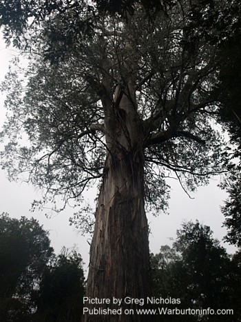
Ada Tree The Ada Tree is approx. 26 km SE of Warburton. Slightly closer NE of Powelltown. Celebrate the Ada Tree experience by making it a day trip. (Thanks GN for feedback. Aug 27th)
If you would rather set a more leisurely pace, stroll through Myrtle Beech rainforest to the ancient Ada Tree. Over 300 years old, the Ada Tree is considered to be one of the largest known flowering trees in the world. It stands at about 76 m tall with a circumference of 15 m measured at 1.5 m above ground level. The Myrtle Rainforest walk is enchanting and educational with many points of interest displayed along an easy walk of 3.2 km taking approximately 1.5 hours to return. If you have time, allow an extra 45 minutes to visit the New Federal Mill - continue 1.4km along the walking track at the Ada Tree |
|


 - Photo by Greg Nicholas")
|
Lala Falls Warburton Approx 3.2km return trip - about 20 mins each way. The ground is not flat but track accessible and is family friendly for people that have average fitness and like a quick bush walk. The track has recently been upgraded and now open again after being closed for several weeks last winter. This new stone walk bridge is a nice piece of work about half way along the track. WarburtonInfo.com always welcomes pictures from locals and the public - but please contact before sending any images of Warburton so we can advise on best way to send :) |
  |
|
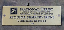
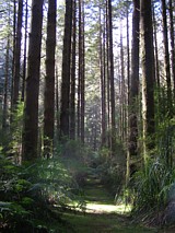
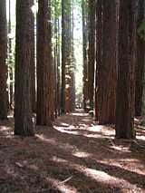
The Redwood Forest About 8kms on the main road from Warburton Post Office, through East Warburton - look for CEMENT CREEK RD on your left - over a bridge - then 0.8km - 1km approx up a narrow and unsealed dirt road. Look for a dirt lay by beside a gate with a very big concrete barrier. You have found the Redwood Forest. Please treat this beautiful area with the respect it deserves. Quiet, peaceful, magical - these 1500 approx giant Californian Redwoods (SEQUIOA SEMPERVIRENS) are listed on the Australian national Trust. They are listed on the register of significant trees of Victoria. Leave the ipod and ipad at home - and don't expect much mobile phone reception (if you get reception - turn your phone off). Just 8kms from Warburton - enjoy an hour or so wandering and wondering in this little piece of magic. When my family visited - we took a simple picnic, sat in the nearby clearing and regarded the trees while we ate. Enquiries for use of Redwood Forest: http://parkweb.vic.gov.au/park-management/applications,-licences-and-permits/event-permits Paul Jackson - warburtonInfo.com
|
|

 |
Handy Tourist Hint: Spend the night and next morning in Warburton then head for Powelltown and the The Seven-Acre Rock Walk - To access the start of the Seven-Acre Rock Walk head west of Powelltown along the main road for 1 km then turn left into Learmonth Creek Rd. Follow it past Kobiolke Rd to the T-intersection with Bunyip Rd turn left and it is 500 m to the start of the track (1.2 km return), opposite the picnic area. It leads to the rock outcrop which is an excellent viewing platform affording views of Westernport Bay, Bunyip Valley and, on a clear day, Port Phillip Bay. Thanks Jim Child for this handy tourist hint! |
|
Big Pats Creek - 7kms from Warburton Post Office - About 4 hour walk return trip from Warburton Post Office. Walk from Post Office east towards the caravan park but turn right into Riverside Drive (at the Adventist Church). Hug the river past the bus depot and continue around for several kilometres on the opposite side to the caravan park until you find and turn right into Big Pats Road. Walk straight ahead past grazing black cattle on some great green pasture (spring 2011) until you enter Big Pats Creek community and the wooden bridge to the right. A lovely little area to rest and regard the river. There are a number of walks from here (see Richards Tramway Walk below) including nearby Big Pats Creek Picnic area and scenic walk beside the river. (Yet to be explored by Paul @ WarburtonInfo.com and his neighbour Greg - without whom Paul would not be discovering these great walks around Warburton) As you will see from this page it would be very easy for visitors to Warburton to easily spend a few days at local Warburton accommodation and enjoy a 2-4 hour walk daily. WarburtonInfo.com always welcomes pictures from locals and the public - but please contact before sending any pictures so we can advise on best way to send :) |
|


|
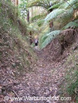
Richards Tramway Walk - 1.5km from Big Pats Creek bridge above- September 2011 The info sign for this walk says 20 mins to the 'top' - but we walked in for 35-40 minutes and - after returning to the sign on the way out - think we almost got to the end. The walk follows the route the saw miller William Richards began constructing in 1916 - to gain access to timber in the Starvation Creek Valley. The walk is reasonably easy and slightly uphill - but not pram friendly and while Grandmas and Granddads will make it up - maybe leave Great Grandma at the picnic area unless she is hardcore. There are one or two cuttings that are a bit wet and like walking in deep drains for 20-30m - even though most of the area is quite dry and north facing. The track is not as well walked as others closer to town and with a number of small and sometimes large trees fallen across the track. There are some good signs along the track documenting the construction of the track, trees that have been struck by lightening and why the track twists and turns, in part because Richard wanted to avoid straying onto neighbouring property and avoid the associated fees the neighbour wanted. There are some fantastic large trees still standing but very burnt from the 1983 Ash Wednesday fires - the country felt drier with more grasses and less ferns - than other walks closer to Warburton and near the Aqua duct. Thanks again to Greg for this walk idea recommended here. Allow two hours from parking the car at Big Pats Creek to walk and regard the tramlines and other points of interest along the way. |
|


|
Always tell business you found them on |
Related category: Warburton Tours Related category: Warburton Accommodation Related category: Warburton Events |
The Warburton trail is a very popular and picturesque attraction. The trail runs all the way from Lilydale to Warburton through some of the most scenic areas in Australia. Bike riders and hikers share the track. Access is readily gained from numerous points throughout the trail, which previously included the 'Home Hotel' at Launching Place. As of Jan-Feb 2018 that access point has now moved and the Home Hotel will no long be an access point, with the carpark and amenities moving further down the road to The Launching Place General Store where ample car parking facilities are available. Staying at a Warburton Valley Bed and breakfast in Seville - also provides nearby access for bikers, walkers or horseriders on the Lilydale Trail. A leisurely bike ride from this point would take approximately an hour to Warburton township where you could venture further to East Warburton or stop and enjoy a coffee in the village. Along the way there's lot's of eating places, a few pubs to quench the thirst and heaps of points of interest. For a great 'Rail Trails' resource - including guide books for VIC and SA Rail trails - see Railtrails Australia
The recently opened ‘O’Shannassy’s Aquaduct Trail’ takes walkers and mountain bike riders through magnificent prestine forest of mountain ash and treeferns from Don Valley to East Warburton – a truly magestic outdoor experience close to nature.
Other walks & things to see & experience are via La La Falls, Warburton Circuit Walk, Cement Creek Walk, Little & Big Peninsula, Upper Yarra Reservoir and many more
Good Wine & Good Food
The Yarra Valley is irresistible, with visitors returning time and again to taste its famous wines and foods. Lush green paddocks and rows of strong vines paint a story book picture of rustic life. Food lovers must stop at Yering Station to meet the food producers at Yarra Valley Regional Farmers market in the Yering Station Barn (third Saturday of each month) or enjoy a cheese platter or tasting of award winning Australian cheeses at the nearby Yarra Valley Dairy. Order a Yarra Valley Platter at restaurants and cafes throughout the Valley, or lunch and/or sample fine wines at one of the beautiful vineyard restaurants.
Explore the wine list and enjoy local foods at the historic Yarra Valley hotels or stoll down the main street of Warburton visiting boutiques and gift shop. Travel via Archeron Way or Maroondah Highway’s ‘Black Spur’ to Marysville to visit Steavensons Falls.
Wineries Via Warburton Highway
There are many smaller excellent boutique wineries scattered throughout the Yarra Valley & Upper Yarra Valley that beckon to be explored. Via Warburton Highway, visit Elmswood Estate Winery and other boutique Seville wineries - The views from Killara Estate capture the panoramic scene of the Yarra Valley’s mountainous backdrop and Bulong Estate’s award winning wines and fine food leave a lasting impression. The Valley’s ‘Home Hotel’ in Launching Place – Victorian Country Pub of the Year – welcomes Warburton Rail Trail walkers & bikers, travellers and locals to experience their country hospitality, as well as Sam Knott Hotel in Wesburn and the Alpine Hotel in Warburton.
Healesville Sanctuary
Tucked into the tree clad foothills of the Yarra Ranges near Healesville, the renowned Healesville Sanctuary offers 30 hectares of bushland to experience Australia's wildlife and is a great introduction to the sights, scents and sounds of the Australian bush. A path weaves through the sanctuary, leading to spacious areas where birds and animals live within their native habitats. Experience a fly-by of colourful King Parrots, stand beside inquisitive kangaroos, observe sleepy koalas and encounter dingoes and their keepers walking along pathways. The Birds of Prey presentation is a must see: a thrill packed 20 minutes that demonstrates the flying skills of various Australian birds of prey. The Healesville Sanctuary features walks through habitat exhibits, flight aviaries and special nocturnal exhibits all finely tuned to showcase the wonderful natural behaviour of our unique Australian wildlife. Healesville Sanctuary is a sensational way to spend a day in the Yarra Valley. As Australia's premier wildlife park, the Sanctuary gives you a personal encounter with Australian wildlife creating experiences you'll take away forever.
More information about the Warburton Hwy Region of the Yarra Valley and the Upper Yarra Valley & Surrounds can be located at the Warburton Information Centre (unrelated to this website) at 3400 Warburton Highway, Warburton, Phone 03 5966 9600.